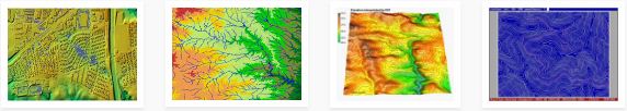
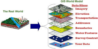
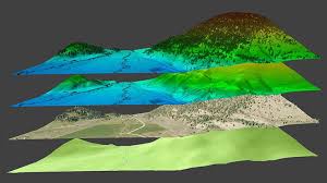
Utility Mapping

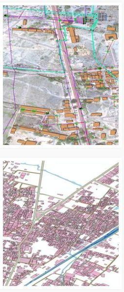
Netxcell has completed Electric asset mapping for several towns in our country, right from DGPS survey to geo-database creation under RAPDRP Project. The methodology adopted for this project:

  • Processing of satellite imagery & geo-referencing of a project area.
  • Creation of satellite imagery base map of a project area.
  • DGPS survey and mapping of each network entity and landmark.
  • Creation of digital network map of a project area.
  • Door-to–door customers survey for indexing and linking with the network entity.
  • Design and collection of entities & customers attribute data.
  • Linking of each customer to its source of power supply on satellite imagery base map.
  • Linking the Customer database with the base map and electricity network entities database with the electricity network map.
  • Establishing a relationship between electricity network entities database and Customer database so that electricity network entities can be referred spatially in relation to geographical/land-based features.
  • Finally creation of PGDB.
Cadastral and Parcel Mapping
  • Netxcell has a large, dedicated digitizing team specialized in rapid and cost-effective parcel mapping.
  • Parcel mapping is the foundation of land boundary identification, ownership and transfer.
  • We provide advanced spatial feature extraction for additional digital attribution using orthophotos.
  • Integration with other land planning databases enables the development of comprehensive Land Information Systems (LIS).
  • Our GIS analysts are specialized in:
    • Coordinate Geometry (COGO) mapping
    • land-use and zoning integration
    • Web-based data and application hosting and development.
GIS Design and Implementation
  • Netxcell excels at providing innovative solutions for spatial data processing and GIS design.
  • We have been involved in dozens of projects, each requiring a new, flexible approach and design.
  • Careful attention is paid to needs assessment, project specifications and data, hardware and software requirements.
  • An initial cost-benefit analysis is often crucial for assessing database design, life-cycle costs, staffing requirements and maintenance costs.
  • The process includes developing a detailed project plan,a design of the data structure and the production, integration and test of the resulting spatial data.
  • Availability and distribution of the final data and the internal GIS architecture are meticulously planned.
  • Custom software utilities are often developed to bridge data conversion gaps, reduce barriers and speed data transformation.
  • Netxcell provides superior project management, continuous client feedback and detailed reports throughout the project lifecycle.

  • Customized GIS Application Development: Netxcell has industry expertise to develop the customize GIS applications to meet the user requirement.The application can be used for spatial database generation and having the facility as per project specifications.

    Netxcell’s customizes Web-based GIS to give your users GIS functionality and products through their Web browser. Netxcell’s Web-based solution integrates with enterprise geospatial and tabular databases to seamlessly give users robust query, analysis, and reporting capabilities. Netxcell has application development tools such as ArcIMS, Map Guide, XML, JavaScript, JSP, ASP, and others.

    Remote Sensing:
    Netxcell’s experienced Staff offer the best Remote Sensing services for natural resource mapping. Executed a number of projects in Image Processing, Image Classification, Vector overlay, Geo-Referencing and Resource Mapping.
    Watershed Mapping

    Netxcell has also involved in rural sector projects like “Impact assessment and monitoring of watersheds” using Remote sensing and GIS techniques and created geo-database for NABARD.

    • The application of RS & GIS in our country have been shown tremendous progress and have established the potential of this technology for natural resources ( soil, water etc. ) management and environmental monitoring in various sectors.
    • High spatial and temporal resolution satellite data could be effectively used for watershed management and monitoring activities at the land ownership level.
    • These techniques are also successfully used for preparing detailed thematic maps, watershed development plans and continuous monitoring of the natural resources in watershed areas.
    • Though conventional methods (surveying) provide information, they are slow, rough data, time consuming and expensive. Among the new technologies emerged for studying natural resources, spaceborne RS technology proved to be powerful.
    • A synoptic view of the terrain features with the high spatial, spectral and temporal resolution satellite data.
    • The GIS application provides an ideal environment for the integration of data and helps in generation of an action plan for the development of watersheds. After implementation of the action plan, multi-temporal satellite data help in monitoring its success and progress
    • High spatial resolution panchromatic and multispectral data may further enhance our capability of generating a farm-level action plan for land and water resources development, and to study the success and progress of the implementation of such action plans.
    Thematic Mapping

    Our work has proven experience and expertise in end-to-end thematic mapping facility that includes the entire spectrum of integrated GIS/ Remote Sensing services and business solutions. Our thematic mapping facility able to deliver the project on small scale to large scale.

    Creation of various thematic maps (spatial data) of a particular area/watershed. This geospatial data can be used for various applications viz. Groundwater Prospects Mapping, determination of suitable sites for construction of recharge structures, Land and water management, Town Planning, agriculture and forestry etc.
    Mine Planning and Geo-database Creation

    Services are provided to clients on a project-by-project basis and under continuous contract. With on-going and extensive mine operational experience, Netxcell is strongly positioned to provide cost-effective, field-proven solutions for reserve and feasibility studies, mine planning and design, mine facility planning and design, capital and operating cost analysis, equipment and systems specifications, project and construction management. Netxcell is committed to providing excellence in sustainable resource development planning and environmental protection.

    Netxcell has industry experts and consultants to deliver such kind of project.

    The onshore team will collect the mine data from the officials from the mine our experts will prepare the mine planning maps and database for a user. Our backend team will create the mining geo-database as per the requirement.

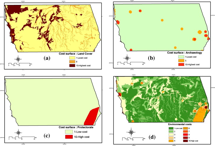
    such geo-database can be useful for a user to know how much ore, mineral can be excavated from it with a cost-effective manner, and how much is already excavated. And this data is also useful for administrators to preserve the valuable ore/mineral. Apart from the above the data also useful to identify & locate the mineralized zone, existing lease details etc.

    LiDAR
    • Netxcell offers a full range of LiDAR data processing services.
    • Our experienced operators utilize the latest hardware and software to process all dataset sizes.
    • Wide levels of automated and manual processing are available, including.
    • Data quality enhancement, detection, removal and reduction of noise and outlying points.
    • Generation of color-coded digital elevation models and contours derived from LiDAR point data.
    • Generation of elevation profiles and digital surface models (DSM) and DTMs as raster, TIN, contour or slope models.
    • Advanced detection and extraction of buildings and features and specific model generation, including coastal zone management, urban planning, change detection and telecommunications.
    • Surface and land use classification and characterization.
    • Integration with other digital data: DEMs, orthophotos, remote sensing images.
    Photogrammetry Services

    Netxcell offers a full range of high-quality photogrammetry services, from small, technically challenging projects to large, high volume work. Netxcell has the capacity and expertise to deliver superior quality results quickly and cost-effectively. With our dynamic approach, we can provide either a complete production solution or phased deliverables as required.

    Our services includes:
    Project management
    Flight planning and GCP surveys
    Aerial photo acquisition
    Scanning
    Aero Triangulation
    planimetric mapping
    Digital elevation and terrain modeling (DEM/DTM)
    Map editing
    Digital orthophotography

    “Project Planning and Management”
    • Experienced project managers liaise with clients and oversee all project stages.
    • Dedication to the technical specifications, delivery schedule and client expectations are key to project success.
    • Rigorous quality control procedures and interim progress reports are standard.
    “Aero triangulation”
    • State-of-the-art Softcopy photogrammetric workstations are used.
    • Automated AT is available but manual AT processing is preferred for its higher accuracy.
    • A root mean square (RMS) error of less than [1/10,000 times flying height] is typical.
    “Flight and GCP Planning and Aerial Photo Acquisition”
    • Detailed flight planning with the optimal amount of ground surveying keeps costs manageable without reducing accuracy.
    • Airborne GPS is used to bolster accuracy and reduce costly field surveys wherever possible.
    • Local survey partners may gather the GCP coordinates while local aircraft use USGS-calibrated cameras.
    • Black & white, color and infra-red photography requirements are all accommodated.
    • Detailed, advanced film inspection is also available.
    "Topographic and Planimetric Feature Extraction”
    • Extraction occurs in a Micro station environment and can be exported to any CAD/GIS format.
    • Planimetric feature extraction follows applicable feature tables or database dictionaries.
    • High-quality DTM, DEM and/or contour files are derived by our team of experienced photogrammetrists.
    • Netxcell has extensive expertise with large and small scale mapping (1″=40’ and smaller).
    "Map Editing”
    • Netxcell delivers innovative map sheet layout and design with advanced contour interpolation.
    • Cleaning and topological structuring of planimetric data is also provided.
    • A variety of cartographic editing, layout and separation processes are available.
    "Digital Elevation and Terrain Modeling (DEM, DTM)”
    • Netxcell excels at high resolution TIN and surface model preparation.
    • Optimal data collection methods and meticulous modelling capabilities are implemented.
    • Automatic contour generation and advanced manual contour smoothing can be performed.
    • Netxcell has expertise in working with hard and soft break lines and high-density mass points.
    "Second Generation Orthophotography Capabilities”
    • Greatly reduced production costs for clients requiring new orthophotos in areas with existing data.
    • Netxcell uses previous DEMs and orthos to derive GCP elevations that allow new aero triangulation adjustment for recent aerial photos.
    • The need to deploy ground survey crews and create new digital terrain and elevation models is greatly reduced.
    "Digital Orthophotography”
    • Netxcell uses the latest, superior quality orthorectification techniques.
    • Advanced methods used to correct camera, lens and relief distortions.
    • Further processing includes precise dodging, mosaicking and global tone balancing.
    • Seamlines are generated automatically and edited manually to ensure seamlessness between the tiles.
    • Special attention is given to bridges to avoid smearing at the stereo compilation level.
    • An intense quality assurance process ensures 100% adherence to customer specifications.
    "Innovative Map Design and Specialized 3-D Modeling”
    • High resolution, 3-D images are created from elevation data and complex triangulated irregular networks (TIN) using the latest, state-of-the-art software and rendering technology.
    • Resultant images are sun-illuminated and terrain and elevation shaded.
    • Applications include resource extraction, infrastructure planning, utility management and recreation usage.
    • These intuitive images provide a rapid appreciation of terrain, grade and natural and man-made features.
    Digitization and Base Map Creation
    Base maps are an integral part of sound engineering practices. Base maps empower us to visualize the relationship between the physical characteristics of an area and the proposed development project. We create layered base maps which include GIS data like highways, roads, streets, bodies of water, satellite imagery and geographical boundaries.
    Netxcell’s development team uses the combination of layers depending on the requirement. We cater to the need of different industries like Engineering, Geology, Government planning, Utility management and Demographic research.
    Import a raw survey data into base map reliably, smoothly and effectively. Our flexible design is an alluring feature which enables designers to visualize multiple scenarios.
    Salient Features :
    Mode of presentation You can use the base map created by us to display it on a computer screen or a TV screen.
    Mapping and Publication Scale We adhere to the International System (SI) units
    Device Compatibility We make the base map compatible with different devices like a desktop or mobile phones etc.
    Ready to be used in natural light Our base maps can be used in natural light allowing the project team to analyze them on the field.
    We use symbols We choose muted colours and symbols to showcase operational layers. Our symbols are clearly explained at the bottom of the map.
    2D and 3D maps 2D base maps are well suited for use with a web browser while 3D maps require GIS application. We deliver both types of base maps with excellence.
    Property Tax Survey

    Geographical Information System (GIS) based survey can be very effective in identifying property tax defaulters. Netxcell offers government agencies a perfect GIS survey which captures every property electronically in their jurisdiction.

    India is going to establish more than 100 smart cities and Netxcell understands the requirement of government agencies in streamlining their services by using IT and ITES. Netxcell’s GIS Survey to assess private and government properties assures transparency and efficiency in tax collection.

    Cities act as the growth engine of a country and mapping private properties with the help of GIS enables a government to deliver e-Governance services efficiently.

    Salient Features of Our Solution:
    • Accurate and computerized database with digitized ward maps.
    • Properties are assigned unique property IDs.
    • The web-based application provides more interactive service delivery.
    • Citizen friendly features with automated online tax calculator.
    • Many friendly features for Urban Local Bodies like daily collection reports, issuing of tax paid details and easy tracking of tax defaulters etc.
    GIS Mapping (3D)

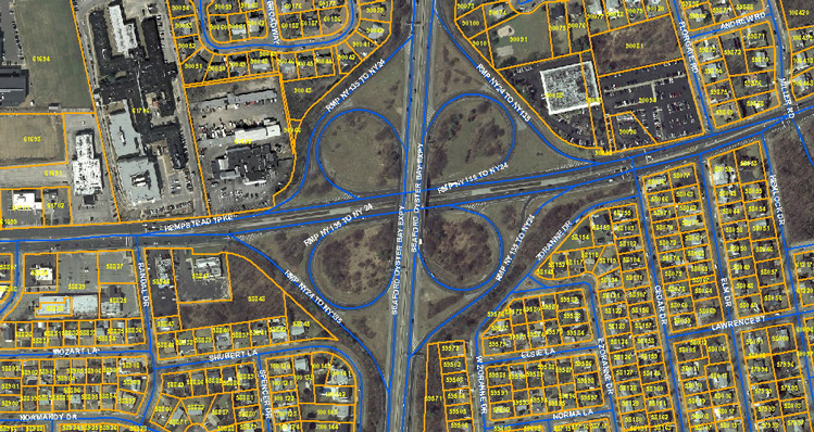
    Netxcell’s GIS mapping services capture and scan geospatial data to integrate database, mapping and statistical methods with geo-referenced data. The integration ensures excellent management to tackle the tough challenges posed by your project. We manage your mapping goals by delivering quality geospatial products.

    Our 3D GIS Mapping services meet the need of the following:
    • Urban Planners.
    • Airport Mapping.
    • Mineral and Agricultural Mapping.
    • Environment Impact Studies.
    • Land Cover Classification.
    Web GIS

    Netxcell empowers enterprises to present their web GIS applications to the entire world. It relies on a simple server and client architecture. The GIS operations, requested by the client are performed on the server. After performing the GIS operation, the server makes use of HTTP to send its outcome to the client.

    • Netxcell promises to give you a platform to present the Web GIS application across the world.
    • Web GIS can be used by many users unlike the conventional Web GIS, hence we provide unmatched scalability and high performance.
    • Web GIS offers a novel way to lower the cost and this is lucrative for organizations.
    • Netxcell’s Web GIS offers easy to use UI.
    • Netxcell’s Web GIS service is apt for diverse applications.
    • Netxcell’s Web GIS application includes:
      • Basemaps
      • Geo-database
      • Multiple Operational Layers
    Drone Survey
    “Cost-effective, Topographic surveys with high-resolution 3-D Mapping”

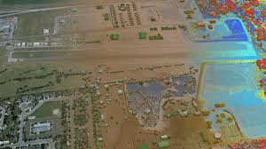
    We deliver accurate surveys with 7X fast speed with multiple ground controls. Our drone surveys make mapping and topographic analysis a cost-effective affair.

    Terrain modelling
    Hydrology assessment
    Aerial photography
    Detailed site exploration

    • Our expertise in the domain helps us deliver quality remote sensing with unmatched digital terrain modelling.
    • In context to developers and landowners we provide vegetation, elevation and hydrology assessment.
    • We handle large UAV’s to capture outstanding and minute details.
    • Interior drone surveys with Lasergrammetry or Photogrammetry enables modelling of huge buildings with better plans and management.
    • Our services range from drones in smart cities to drones in deep mines.